


SityTrail - Rocher Blanc 7 Laux

raymondfn
User
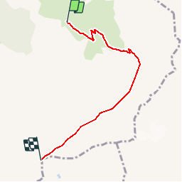

Length
5.1 km

Max alt
2902 m

Uphill gradient
1108 m
Km-Effort
16.2 km

Min alt
1784 m

Downhill gradient
0 m
Boucle
No
Creation date :
2019-08-01 17:25:05.433
Updated on :
2019-08-01 17:31:34.908
3h41
Difficulty : Difficult

FREE GPS app for hiking
 SityTrail
IGN / Geographical institutes
SityTrail Plus
The world is yours!
About
Trail Walking of 5.1 km to be discovered at Auvergne-Rhône-Alpes, Isère, Le Haut-Bréda. This trail is proposed by raymondfn.
Positioning
Country:
France
Region :
Auvergne-Rhône-Alpes
Department/Province :
Isère
Municipality :
Le Haut-Bréda
Location:
La Ferrière
Start:(Dec)
Start:(UTM)
273569 ; 5016436 (32T) N.
Comments